Climate of Laos
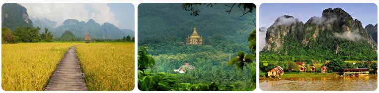
Where is the country of Laos located? The Democratic People’s Republic of Laos, almost always referred to as Laos, is a country in southeastern Asia. The country is completely surrounded by China, Vietnam, Thailand, Cambodia and Myanmar and has no coastline. The country does have a large number of rivers, some of which flow into the South China Sea. The main river is the Mekong, which lies almost entirely along the border with Thailand and eventually flows into Cambodia. Laos has for the most part a tropical savanna climate (type Aw according to the Köppen climate classification). The east has an area with a tropical monsoon climate and the extreme north has a warm China climate (type Cwa), with precipitation amounts of more than four hundred millimeters per month in the summer period.
Temperatures
Laos mainly consists of rough mountainous terrain, along the western border with Thailand you will find lower areas. The Mekong River forms the lowest area of Laos, with an average elevation of about 70 meters above sea level. The many differences in height (the highest point is at 2817 meters) provide a capricious precipitation picture, with the windward side of a mountain sometimes being ravaged for days by rain showers and the leeward side is virtually dry for days at the same time. You can also see significant differences in the course of temperature due to the differences in height and the variations in geographical location. In places where rain has little chance, it can get quite hot in the summer months, while on the windward side of a mountain, where it does rain at that time, it can be five to ten degrees cooler.
Rainy season
There is a big difference in the number of days with precipitation and the amount of rain that falls in the driest months of December and January and the amounts of precipitation that are measured in the period May to September. On average, in the rainy season (from the start) there is about 250 to 350 millimeters of rain per month, in the north this can rise to more than six hundred millimeters locally in the wettest months. In October the weather changes quickly when dry air is brought in from the north. From that moment on, rain is a phenomenon that you will not have to deal with much until April.
Hurricanes
Laos has a chance of hurricanes during the hurricane season (which runs from June to December). Laos is located in the supply route, but because the country is a bit further inland and is ‘protected’ by mountains, the number of hurricanes that actually reach Laos with hurricane force is very small. If a hurricane does hit Laos, it usually means a trail of destruction and casualties, as in September 2009, when Hurricane Ketsana caused a lot of misery in Vietnam, Cambodia and Laos.
Climate figures
The figures below are based on long-term average climate statistics. The temperatures are displayed in degrees Celsius (°C).
| Maximum temperature | Minimum temperature | Hours of sunshine per day | Days of rainfall per month | |
| January | 29℃ | 16℃ | 8 | 2 |
| February | 32℃ | 18℃ | 8 | 3 |
| March | 35℃ | 21℃ | 8 | 5 |
| April | 36℃ | 24℃ | 8 | 9 |
| May | 34℃ | 24℃ | 7 | 17 |
| June | 33℃ | 25℃ | 5 | 19 |
| July | 32℃ | 25℃ | 5 | 20 |
| August | 32℃ | 24℃ | 5 | 22 |
| September | 32℃ | 24℃ | 5 | 19 |
| October | 31℃ | 23℃ | 8 | 9 |
| November | 30℃ | 19℃ | 8 | 2 |
| December | 29℃ | 16℃ | 8 | 1 |
Best time to visit Laos
Do you want to know when is the best time to travel to Laos? You can determine the best time to travel to a destination based on the weather and climate. In addition, there are other factors that are not directly related to the weather and that can influence the best travel periods for a travel destination. Think, for example, of holidays or festive periods, which makes traveling more interesting or not, because daily life comes to a standstill as a result. Laos is the only landlocked country in Southeast Asia. This makes the Mekong River the country’s main waterway. Laos has a mix of tropical climates and China climates. The country is quite mountainous. The highest mountains reach heights of more than two kilometers. The landscape means that there can sometimes be significant differences in precipitation patterns within Laos. The wettest places in the country can receive up to almost four thousand millimeters of rain per year, while the drier destinations remain at roughly 1300 to 1400 millimeters on an annual basis. One thing applies to the whole country and that is that there is a dry period and a rainy season. During the rainy season, significant amounts of rain can fall.
Best months
The most suitable travel time for a holiday in Laos is from November to March. Since March can be seriously warm (33 to 35 degrees Celsius as an average maximum temperature) and November can still be unstable due to tropical depressions, December to February is the best time to travel to Laos.
The rainy season
After the hot months of March and May, the monsoon in May causes the rain to cool down. In May and certainly in June, the number of rain showers increases and the temperature drops slightly. In terms of feeling, it does not get much cooler, because the relative humidity makes it feel clammy. Mid-July to mid-September is the wettest and gloomy period in Laos. This ensures that the summer holidays are actually the least suitable travel period for a tour through Laos. Too bad for those who are stuck with the school holidays. After all, the summer holidays are the only school holidays where you can travel for longer than two weeks.
Cyclones
In the period from mid-May to mid-December, tropical cyclones can affect the weather in Laos. Such a severe tropical storm, which in this part of the world is called a typhoon, will not easily reach Laos with hurricane force. However, a hurricane that reaches neighboring Vietnam can cause extraordinary amounts of rain and strong winds in Laos.