Climate of Canada
Where is the country of Canada located? Canada is a country in North America. Most of Canada has a continental climate, which is also referred to as a continental climate. The moderate continental climate and the cool continental climate are the most common. In the northern parts of Canada this changes into the tundra climate (the ET climate within the Köppen climate system). Above the Arctic Circle there are areas where it is so cold that there is an ice climate or snow climate (EF climate).
Canada is the second largest country in the world. At nearly 10 million square kilometers, it beats China, the United States and Brazil. At just under 17 million square kilometers, Russia is a lot bigger. Despite its enormous size, Canada does not have that many different climatic regions. This is mainly due to its location, which is relatively far from the equator, and the limited number of factors that influence Canada’s climate.
The Rocky Mountains in the west of the country are important: on the one hand, they ensure that depressions cannot reach the interior east of this mountain range. This also creates a virtually free passage for areas with cold arctic air to travel deep into the Canadian interior. Temperatures can drop to values of minus 30 to minus 40 degrees in the winter months during the supply of very cold arctic air. Sometimes it gets even colder and villages are completely cut off from the outside world.
Influence of the oceans
The currents in the oceans are another element that greatly influences Canada’s climate. In the west, the Kuroshio provides the supply of relatively warm seawater, making the west coast of Canada a lot warmer and more pleasant than the east coast, where relatively cool seawater is supplied via the Labrador Current. In the province of British Columbiathe weather is therefore a lot milder in character. In the summer, most of the heat is moderated by the seawater, but in the winter the sea and mountains mean that the coastal region in southwestern Canada has mild winters, with average temperatures staying above freezing all day long on many days. . This makes this part of Canada considerably warmer during the winter months than all other regions of Canada, where it is cold to very cold in winter.
Travel to Canada
Canada is a destination that you can travel to all year round. Those who want to make a tour through Canada will mainly travel in the period from May to September, because the roads are the best passable then. In the autumn and spring, however, the Canadian cities are very worthwhile and during the entire winter season you can enjoy winter sports in Canada. Keep in mind that you have your travel documents for Canada in order on time. For example, you must apply for an eTA Canada in time if you want to travel to Canada without a visa. Be sure to arrange your rental car or motorhome on time. Rent a motorhome in Canadapreferably before Christmas if you want to tour Canada in the middle of summer. Especially in high season, availability is often very limited if you book late.
Climate zones
Most of Canada has a continental climate according to the Köppen climate system, ranging from a moderate continental climate in some southern parts of the country, passing through a large zone with a cool continental climate to a subarctic climate (type Dfc). The north and northeast of Canada have a tundra climate (type ET). Here the winters are very cold, the summers cool and there is little precipitation.
The Rocky Mountains in the west partly have a high mountain climate, with large areas where there is eternal snow and the temperature in the summer months does not or hardly rise above freezing. Within the Rocky Mountains you also have lower areas where a cool continental climate (type Dsc) occurs.
Along the west coast there is a temperate maritime climate (type Cfb) with mild winters, warm summers and reasonable amounts of precipitation, of which there is more in winter than in summer, but there is no real dry season.
Wintery
Canada experiences cool to very cold winters, with the exception of the west coast, where the warm seawater keeps it from cooling too much. The Rocky Mountains here ensure that cold polar air from the interior cannot reach the coastal areas in the west. In terms of temperature and weather, western Canada is therefore one of the most stable regions in winter. There is, however, a great chance of precipitation due to the supply of sometimes very large depressions from the sea. Because these stick to the mountains, you have fairly high precipitation averages in most places. The winter period in the west is the wettest period of the year, with an average of more than a thousand millimeters of precipitation in the form of rain, snow, sleet and hail (October to March).
In central Canada, winters are cold without exception. The greatest variation is mainly in how cold it eventually gets, which is mainly determined by how strong the supply of very cold Arctic air is from the north. In the northern part of central Canada, temperatures of minus 20, minus 30 or even minus 40 are very common during the period November through March. The south is normally less cold, unless there is a strong current of cold air moving south and temperatures can drop to well below freezing as far as deep into the United States. Southeastern Canada has the most unpredictable winter weather. The thermometer can rise above freezing in many places during the day, but especially a bit inland, where you will find the big cities such as Quebec and Toronto, it can also get quite cold. Weather maps with deep depressions and low temperatures are regularly interspersed in the winter months with depressions in which large amounts of snow are brought in and periods of (light) thaw, which unfortunately are often quite short-lived for the local population.
Warm summer months
Summers in Canada are quite warm in many places. In the west, the summers are comparable to the Netherlands. In cities such as Vancouver and Victoria it is about 20 to 25 degrees during the day and the temperature drops to about 10 to 15 degrees at night. The summer there is relatively dry, with about 40 to 60 millimeters per month. Temperatures in this area can rise to around thirty degrees, but it does not get much warmer. Even in a place like Dawson, halfway through Yukon, quite close to the Alaska border, a high of 20-25 degrees is quite common in July, the warmest month in this region. At the end of August, the first night frost can occur again and a month later it can also freeze for the first time during the day.
Where it can get quite warm is in the south of Canada. Because the sea has virtually no influence on the weather here, the sun has free rein to raise the thermometers to 22 to 30 degrees on average, with sometimes significant peaks of up to 40 degrees in Ontario. Eastern Canada (Nova Scotia and Newfoundland) can be compared with the Netherlands in terms of temperature. Under the influence of a strong supply of sometimes very large depressions from the northeastern tip of the United States, this area is a lot wetter. On average there is also in summer one hundred millimeters per month here, locally even more. This region is therefore not the most suitable for a beach holiday.
Northern Canada – especially the part above the Arctic Circle – is cool in the summer too. The extreme northeast, where you’ll find Ellesmere and Devon, is covered in a permanent layer of ice. Every year there is a period of about forty to sixty days when there is no frost. During very cool summers, this period can be greatly shortened. During the hottest days, a maximum of 10 to 12 degrees Celsius is measured in this coldest region of Canada.
extreme summer
At the end of June 2021, Canada experienced extreme summer weather. In the west, temperatures rose to values that you would expect in Dubai or Las Vegas. The south west in particular was hit hard. Record temperatures were recorded in Lytton (British Columbia). After official temperatures of 46.1 and 47.9 degrees were recorded on two consecutive days, the heat record was broken again on Tuesday, June 29. It was then 49.6 degrees Celsius. Forest fires started due to the extreme weather conditions. On June 30, one of these wildfires reached Lytton and reduced much of the village to ashes.
Precipitation
There are very large differences in precipitation in Canada. The northern part (around and above the Arctic Circle) is very dry, with about one hundred to two hundred millimeters of precipitation per year, almost all in the form of snow.
The interior, between the Rocky Mountains in the west and Hudson Bay in the northeast, is also dry. An average of 250 to 500 millimeters falls here on an annual basis. The southeastern part of the state of British Columbia is slightly wetter. Significantly greater amounts fall along the east coast and on the western side of the Coast Mountains. With about 700 to almost two thousand millimeters per year, quite a lot of precipitation falls here. Canada’s west coast is the wettest, with over two thousand millimeters of precipitation a year, much of it in the form of rain. Unlike tropical destinations, where precipitation often falls in the form of showers, longer periods with many hours of rainfall can occur here. Although the summers are not exactly dry,
Wind
Northeastern Canada regularly experiences storms, which are the result of deep depressions that are brought in along the east coast of America. Even hurricanes or remnants of hurricanes are possible. It can be quite haunting during storms along the east coast of Canada, especially if large amounts of rain are carried along.
Snow storms are another type of wind. These so-called blizzards regularly ravage the eastern part of Canada.
Climate figures
The figures below are based on long-term average climate statistics. The temperatures are displayed in degrees Celsius (°C).
| Maximum temperature | Minimum temperature | Hours of sunshine per day | Days of rainfall per month | Water temperature | |
| January | -5℃ | -14℃ | 3 | 13 | 3℃ |
| February | -4℃ | -13℃ | 4 | 11 | 2℃ |
| March | 3℃ | -6℃ | 5 | 11 | 2℃ |
| April | 11℃ | 1℃ | 6 | 11 | 3℃ |
| May | 18℃ | 8℃ | 7 | 12 | 7℃ |
| June | 24℃ | 13℃ | 8 | 12 | 13℃ |
| July | 27℃ | 16℃ | 9 | 11 | 19℃ |
| August | 25℃ | 15℃ | 8 | 12 | 21℃ |
| September | 20℃ | 10℃ | 6 | 11 | 19℃ |
| October | 13℃ | 5℃ | 4 | 12 | 14℃ |
| November | 6℃ | -1℃ | 3 | 14 | 9℃ |
| December | -1℃ | -9℃ | 3 | 15 | 5℃ |
Best time to visit Canada
Do you want to know when is the best time to travel to Canada? You can determine the best time to travel to a destination based on the weather and climate. In addition, there are other factors that are not directly related to the weather and that can influence the best travel periods for a travel destination. Think, for example, of holidays or festive periods, which makes traveling more interesting or not, because daily life comes to a standstill as a result. When you realize that Canada is the second largest country in the world with almost ten million square kilometers in area, you will understand that it is quite difficult to indicate a best time to travel for the entire country. An advantage that Canada has is that there is a large common denominator: in the winter it is cold to very cold, except for Vancouver and the surrounding area. This ensures that you can already exclude the winter period as the ideal travel period for a holiday to Canada. There is one exception to this and that is if you want to travel to Canada for winter sports. Because of course a country with many mountains and a long period of winter conditions has something to offer people who want to ski, snowboard or cross-country ski.
Best months for Canada
If we have to designate a general period for a holiday in Canada, it is from mid-June to mid-September. This is the warmest period in the country and also the period in which hardly any roads are closed due to snow, ice or mud. This is especially the case in the period November to April. What not everyone knows is that the end of winter is often worse than winter itself. The large amount of melt water can cause muddy roads.
Peak season
Peak season, especially for Canada’s beloved southwestern areas, falls in mid-summer. June and August are relatively busy in Canada. This means that you have to rent your motorhome on time (preferably the previous December) if you want to travel around with a motorhome. It also doesn’t hurt to book campsites in popular areas, such as Rocky Mountain National Park, well in advance. They are very busy in the middle of summer.
City trips
Do you want to make a city trip to a Canadian city such as Calgary, Toronto, Montreal or Vancouver ? That is possible in the middle of summer, but we would rather opt for June or September. These are the months in which the temperatures are pleasant, but in which the chance of heat is a lot smaller than in July or August. The prices for airline tickets are usually slightly more favorable in June and September.
Winter sports
Canada is an excellent winter sports country. It is not for nothing that the Winter Olympics have already been held here twice. Canada has several winter sports areas that are very snow-sure and almost guaranteed to provide a great skiing holiday. The most famous ski areas are located in the Canadian Rockies: Whistler, Jasper and Banff National Park. You can often hit the slopes in November and the winter sports season ends in May in most places. The period from December to April is the best time to travel for a winter sports holiday in Canada.
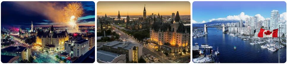
Best time to visit Toronto
Do you want to know when is the best time to travel to Toronto? You can determine the best time to travel to a destination based on the weather and climate. In addition, there are other factors that are not directly related to the weather and that can influence the best travel periods for a travel destination. Think, for example, of holidays or festive periods, which makes traveling more interesting or not, because daily life comes to a standstill as a result. Whoever thinks of Canada of vast landscapes with impressive mountain ranges and beautiful lakes will find a considerable contrast with that image in Toronto. Toronto is a huge metropolis with high-rise buildings, neon lighting and traffic problems. Some find Toronto a nice alternative to the American city of New York City. The fact is that a few days in Toronto will especially excite you. You can enjoy shopping here, enjoy culinary delights and visit various beautiful sights. Toronto can be done on sight as a city trip. Many people choose to combine a trip to Toronto with a tour of eastern Canada. Toronto has a moderate continental climate, where the average temperatures and other weather data are really averages. Particularly in terms of temperatures, there can be significant outliers upwards and downwards. Think of the risk of severe frost in the winter, but also of considerable heat in the summer. In the summer months it can occasionally get warmer than 40 degrees, while in the winter period record cold of as much as minus 30 degrees is possible. Heavy snowfall is also among the options for the winter. In an average winter, Toronto has about 120 to 130 centimeters of snow. There are days with tens of centimeters of snow within 24 hours. During snow storms, daily life in Toronto is severely affected. It is not for nothing that an underground city has also been built within Toronto.
The best months to visit Toronto
If you want to visit Toronto, late spring and early fall are the best times to do so. Actually the period from the moment nature blooms to the weeks when the trees get their autumn colors, but then leave the hot summer months behind. The best months for a Toronto vacation are therefore mid-April to mid-October, with a heat warning for July and August. You can visit Toronto during the two hottest months, but you will have to take possible heat into account. The average maximum temperature in the middle of summer is around 26-27 degrees in Toronto.
Precipitation
The precipitation pattern seen within the climate statistics for Toronto shows a fairly even distribution of precipitation within this Canadian city. In practice, this means that you have a somewhat comparable chance of precipitation every month. In February and March there is slightly less precipitation, but the number of days with precipitation is about the same. If you’re going on vacation to Toronto, make sure you’re prepared for both dry and wetter weather.
Best time to visit Vancouver
Do you want to know when is the best time to travel to Vancouver? You can determine the best time to travel to a destination based on the weather and climate. In addition, there are other factors that are not directly related to the weather and that can influence the best travel periods for a travel destination. Think, for example, of holidays or festive periods, which makes traveling more interesting or not, because daily life comes to a standstill as a result. The city of Vancouver has the most pleasant climate in Canada. In the winter months this is generally the hottest place in the country and in the summer the temperatures are somewhat tempered, making it not easy to get really hot. Partly due to the mild maritime climate, Vancouver has been one of the most liveable cities in the world for many years. For quite a lot of people who make a tour through western Canada, Vancouver is the start and/or end point. The temperate climate is due to the relatively warm sea current. The Kuro-Shiro-Drift supplies warm seawater from the southwest, which means that it can’t get really cold in Vancouver in the winter. That doesn’t mean it’s never winter. Also in Vancouver, temperatures can dip below freezing. Sometimes it can even freeze moderately or severely.
Best months for Vancouver
The best time to visit Vancouver is from mid-May to late September. This is the driest and warmest period in Vancouver. It is also the period with the highest number of hours of sunshine. The month of July is the sunniest month, followed by August. Since these two months are also the driest and warmest, these are our preferred travel months for Vancouver. The average maximum temperature is then around 22-23 degrees. Periods with midday temperatures between 25 and 28 degrees occur regularly. Tropical days do occur, but are not as common in Vancouver.
Differences within metropolitan Vancouver
Within the metropolis of Vancouver you see fairly large differences in the weather. North Vancouver is clearly wetter, grayer and cooler than Downtown Vancouver. In North Vancouver you will find the famous Capilano Suspension Bridge. The weather difference is quite noticeable due to the short distance between these two spots. Somehow, clouds on the north side of Vancouver linger longer, making it rain more and more. In the North Shore Mountains you can even ski in the winter, while in Vancouver itself there is hardly any snow. Cypress Mountain, Grouse Mountain, and Mount Seymour are just a few miles north of downtown Vancouver. These are excellent ski areas where you can often ski or snowboard from late November to mid-April.