Climate of Peru
Where is the country of Peru located? Peru is a country in the western part of the continent of South America. The west and southwest consists mainly of mountain areas (Andes Mountains), with a relatively narrow strip of low coastal area west of the mountains. The east and north consist of low plains separated from the Pacific Ocean by the Andes Mountains. Thanks to the interaction between the Pacific Ocean and the Andes Mountains, a separate system is created along the coastal strip of Peru in which the amount of precipitation is reduced to tens to about two hundred millimeters on an annual basis, but the total number of hours of sunshine is also quite limited due to rising fog. and clouds from the sea. This applies especially to the northwest of Peru, further south you are much less bothered by this. Directly along the coast there is often very persistent fog, which is called garúa. This type of fog is characteristic of the low-lying areas west of the Andes and is caused by the relatively cool seawater that the fog blows onto the land. In the cool period (May to October), this phenomenon creates an almost permanent layer of fog in the lower areas of the mountains, so that the traditional Indians often chose to live in the higher parts of the mountains., where it is sunny and dry.
Climate types
Because it is so dry west of the Andes, there is a combination of a warm desert climate (type Bwh) that changes in a southerly direction into a cold desert climate (type Bwk), because the average annual temperature there meets the criterion of a minimum average annual temperature of 18 degrees Celsius. The Andes Mountains have climate types that range from desert and steppe climates to warm and temperate marine climates. The northeastern part of Peru is part of the Amazon region, here you have to deal with tropical climates, such as the tropical rainforest climate (type Af according to the Köppen climate classification) and in some areas a tropical savanna climate or tropical monsoon climate. The rainfall in the region is much higher than in the rest of Peru, according to the city of Iquitoson average more than 2800 millimeters per year. In this region, the period from June to September is the drier season, although you should see the word dry here as relative and certainly not as an absolute dry season.
Temperatures
In the Amazon region of Peru (the lower area east of the Andes Mountains), the daytime temperature is around the fairly constant value of 30 to 33 degrees Celsius almost all year round. Due to the high relative humidity it feels constantly hot and clammy. In the ‘dry months’ the maximum temperatures can rise a bit further. The 35-degree limit is regularly reached and sometimes exceeded, especially in July and August. In the Andes Mountains, the temperature is mainly determined by the altitude. The average annual temperature in the valleys is often between fifteen and twenty degrees, while it can be below freezing on the upper mountain peaks. West of the Andes the temperature is lower than on the east side, which is mainly due to the Peru Current (Humboldt Current), which supplies relatively cool seawater from the south. The southern coastal towns have an average afternoon temperature of 21 to 26 degrees (warm months coincide with the Dutch winter) and 23 to 28 degrees along the northern coastal areas.
Peru tour
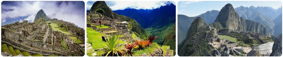
The best way to get to know Peru is through a tour. This way you can discover a number of highlights of the country and you have enough impressions to really get to know the country a bit. Highlights during a Peru tour are of course Machu Picchu and Lake Titicaca. You can book a tour to Peru at ANWB Reizen, among others. This travel organization is a subsidiary of ANWB that specializes in offering tours with Dutch guidance.
View the Peru tours of ANWB Reizen
Climate figures
The figures below are based on long-term average climate statistics. The temperatures are displayed in degrees Celsius (°C).
| Maximum temperature | Minimum temperature | Hours of sunshine per day | Days of rainfall per month | Water temperature | |
| January | 26℃ | 19℃ | 6 | 4 | 22℃ |
| February | 27℃ | 19℃ | 7 | 4 | 23℃ |
| March | 26℃ | 19℃ | 7 | 3 | 22℃ |
| April | 24℃ | 18℃ | 7 | 2 | 21℃ |
| May | 22℃ | 16℃ | 5 | 2 | 19℃ |
| June | 20℃ | 15℃ | 2 | 2 | 19℃ |
| July | 19℃ | 15℃ | 1 | 2 | 18℃ |
| August | 18℃ | 15℃ | 1 | 2 | 17℃ |
| September | 19℃ | 15℃ | 2 | 3 | 17℃ |
| October | 20℃ | 15℃ | 3 | 4 | 17℃ |
| November | 22℃ | 16℃ | 4 | 4 | 19℃ |
| December | 24℃ | 18℃ | 5 | 5 | 21℃ |
Best time to visit Peru
Do you want to know when is the best time to travel to Peru? You can determine the best time to travel to a destination based on the weather and climate. In addition, there are other factors that are not directly related to the weather and that can influence the best travel periods for a travel destination. Think, for example, of holidays or festive periods, which makes traveling more interesting or not, because daily life comes to a standstill as a result. The Republic of Peru is located on the western coast of South America. The Pacific Ocean or Pacific Ocean here has a huge influence on the weather in Peru. It ensures moderate temperatures and low rainfall in the coastal regions of the country. The relatively cold Humboldt Current blocks the flow of rain from the Pacific Ocean. In addition, the relatively cool seawater ensures that the sun shows very little in the winter, but that during the rest of the year fog can regularly be observed in the morning. You can divide Peru into three zones: the desert-like coastal strip, the Andes mountains that run parallel to the coast and the wet tropical interior east of the mountains. The hilly area in the east is partly part of the Amazon basin. Because the different areas within Peru each have their own pattern with regard to precipitation and temperatures, it is impossible to indicate one period as the best time to travel to Peru.
The coast
The coastal strip of Peru has a unique climate. This is one of the driest regions of the entire American continent. In the capital Lima, for example, it almost never rains. The places elsewhere on the coast where rain does occur, the amounts are very limited. Think of a few tens of millimeters to a maximum of about a hundred millimeters of precipitation per year. It does not snow on the coast. What is striking is that in some places it is almost always cloudy in winter. If there are no clouds, then there is often fog or mist. The lack of sunshine in combination with a high relative humidity means that it can feel cold, despite the daytime temperatures reaching up to twenty degrees. The best time to travel to the Peruvian coast is fromNovember through April. The sun shines regularly and with maximum temperatures that are usually between 22 and 28 degrees, it is pleasantly warm.
The Andes Mountains
In the mountainous region of Peru, the Andes, there is a drier and a wetter season. How wet that depends on the location. In western Arequipa, for example, there is an average of about 100 millimeters of precipitation, while in Cusco it is already more than 700 millimeters. The local summer (our winter) is the wetter period in the Andes. The temperatures in the Andes are fairly constant within the year. The altitude determines which temperatures prevail. The best time to travel to the Andes Mountains is from May to October.
The tropical interior
The interior of Peru consists almost entirely of rainforest. Here you have to deal with tropical climates, with the rainforest climate most prevalent. This part of Peru is much wetter than the rest of the country. The annual amounts of rain here amount to thousands of millimeters. The wettest spot is Quince Mil, which lies between the Andes and the lower interior. Up to 6500 millimeters of rain can fall here per year, because the clouds hang against the mountains and rain completely empty. If you want to visit the interior of Peru, the months of July and August are the least wet, making this the best time to travel around this part of Peru.